Mackinac Island often gets described as “lost in time.” After all, with streets full of horse-drawn carriages and lined by Victorian architecture, the car-free destination looks like it belongs in the 1800s. That’s a big part of Mackinac Island’s perpetual charm.
And yet, the 19th century is relatively recent compared to the full scope of Mackinac Island history. It’s basically just a blink of an eye into the past!
What if we look further back in time, before there were Mackinac Island fudge shops and hotels and military forts? What would we find?
The pilot version of a virtual reality map created by a Michigan native offers a glimpse into the history of Native Americans on Mackinac Island. At the same time, the award-winning project by Madeline Gupta explores the idea that Native American history on Mackinac Island isn’t just something from the past, but an ongoing experience that’s continuing today and into the future.
“I’m really interested in this idea that you can change how native people are seen in history,” says Gupta, now a Google engineer. “I want to convey this idea to the world that native histories are not just in the past. You can change the timeline that people are seen in.”
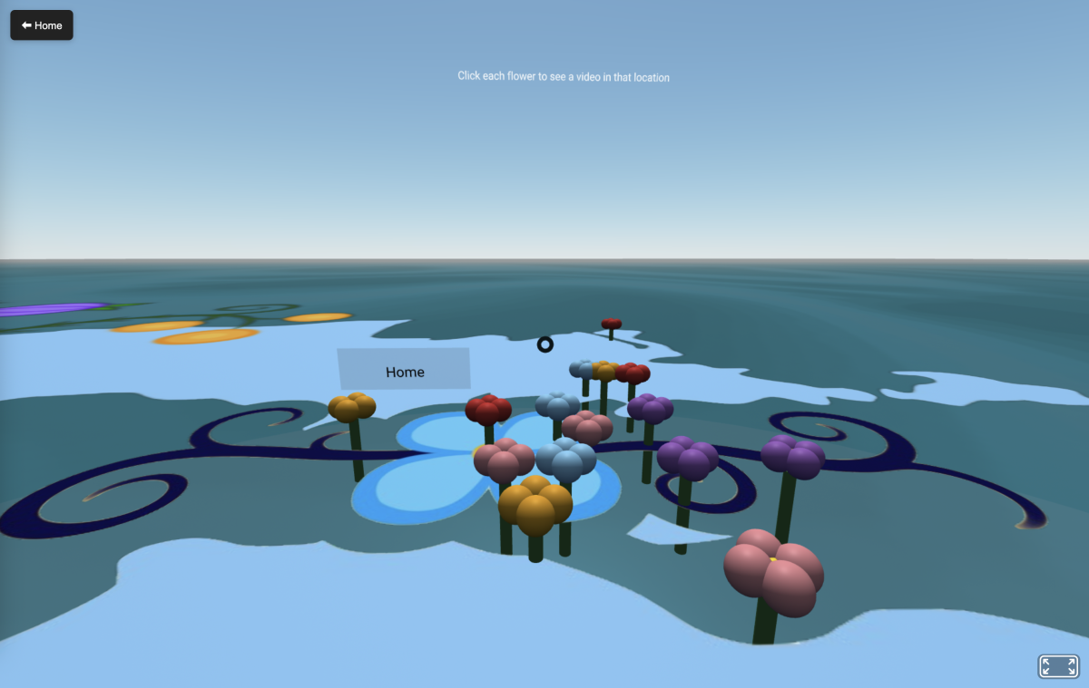
Mackinac Island: Island Of The Fairies
The Island Of The Ferries VR map, designed by an Anishinaabek artist, features dozens of clickable links to northern Michigan landmarks including many on Mackinac Island. Each destination on the map showcases a still image or video overlaid with native stories, songs or poems.
For example, a video of Mackinac Island’s iconic Arch Rock (which is many thousands of years old) is paired with an Anishinaabek creation story of how people eons ago were evil and needed to be wiped out so the world could begin anew.
The video, which shows the stationary rock set against the flowing, tropical-blue water of Lake Huron, provides a digital archive of what an important Native American place looks like on Mackinac Island today. In addition to preserving an indelible image of Arch Rock for future generations, the video also forever imbues the popular attraction with a sense of the Native American cultural significance tied to it.
By using virtual reality technology, Gupta hopes the map communicates that Native American connection to Arch Rock far into the future.
“I really want people, whether they’re native or not, to have a new foundation on how they think about the history and people of Michigan,” Gupta says. “‘Michigan’ is actually a native word for the land that we’re on. Native words are actually in our everyday vocabulary. We just don’t realize they are.”

Mackinac Island’s VR Map Maker
Gupta was born and raised in Michigan and often visited Mackinac Island with her family while spending summers with grandparents in the Upper Peninsula. She recalls feeling a strong connection to her ancestors while on Mackinac Island and hopes the map can share that experience with other native peoples who may never have been able to visit.
The virtual reality Island of the Fairies map can be viewed on mobile, laptop or with VR goggles. Gupta aspires to film more Mackinac Island sites in the future to expand the map, and she hopes her open-source coding for the project will empower other people to create maps that reclaim and reimagine their own past, present and future.
Learn More About Mackinac Island’s Award-Winning Digital Storytelling Map
RELATED MACKINAC ISLAND BLOGS: